This post contains affiliate links. We may earn a commission if you make a purchase, at no extra cost to you.
I remember the first time I dropped into the White Rim Trail’s Shafer switchbacks in my F150. My buddy was in the passenger seat gripping the oh-shit handle while I white-knuckled it down 1,200 feet of exposed cliff-edge road. That’s when I realized Utah doesn’t mess around with its overlanding routes.
Originally published February 19, 2024. Last updated December 3, 2025 with improved route details, camping logistics, and firsthand experience.After running trails across Utah for the past few years, from easy scenic drives to technical rock crawling near Moab, I’ve learned which routes are actually worth the drive and which ones are overhyped. This state has some of the best overlanding in the country, but you need to know what you’re getting into before you commit to a multi-day backcountry trip.

In this guide, I’m breaking down seven Utah overlanding routes I’ve either driven personally or researched extensively through trusted sources. You’ll get real difficulty ratings, vehicle requirements, camping logistics, and the stuff nobody tells you until you’re already stuck or turned around.
Quick Answer: Best Utah Overlanding Routes by Skill Level
Beginner-Friendly (Any Vehicle):
- Alpine Loop Scenic Byway (20 miles, paved/maintained gravel)
- Mirror Lake Highway (42 miles, paved)
Intermediate (High-Clearance Recommended):
- Burr Trail (66 miles, mix of pavement and dirt)
- Moki Dugway to Valley of the Gods (17 miles, maintained dirt)
Advanced (4WD Required):
- White Rim Trail (100 miles, technical sections)
- Hole-in-the-Rock Road (57 miles, remote and rough)
- Lockhart Basin (60 miles loop, very technical)
Now let’s dig into what makes each route special and whether it’s right for your rig.
Understanding Utah Overlanding: What You Need to Know First
Utah’s a weird mix of tourist-packed national parks and absolutely empty BLM land. You can be at Arches watching tour buses unload, then drive 30 minutes down a dirt road and not see another soul for three days.
The basics you need to know:
Permits are everywhere. Unlike a lot of western states, Utah requires permits for many backcountry routes. White Rim needs reservations months in advance. Some BLM roads are free-for-all. Do your homework before you go.
Water is scarce. This is high desert. I carry a minimum of 2 gallons per person per day, plus extra for the radiator. Your truck’s gonna run hot on these climbs.
Cell service is a fantasy. Download your maps in Gaia GPS or onX Offroad before you lose signal. And you will lose signal.
Spring and fall are prime. Summer temps hit 100°F+ in the desert. Winter closes high-elevation routes. March-May and September-October are your best windows.
The rock eats tires. Utah’s sharp sandstone and shale will puncture sidewalls if you’re not careful. I learned this the expensive way on my second Utah trip.
Beginner Routes: Start Here If You’re New
1. Alpine Loop Scenic Byway
Distance: 20 miles | Time: 2-4 hours | Difficulty: Easy | Season: Late June – October
This is where I send everyone who’s new to Utah overlanding. The Alpine Loop runs through the Uinta-Wasatch-Cache National Forest between American Fork Canyon and Provo Canyon. It’s mostly paved with some well-maintained gravel sections.
What makes it great: You get legitimate mountain scenery without needing a hardcore rig. My buddy did it in a Subaru Outback with no issues. The route peaks at 8,000 feet and gives you views of Mount Timpanogos and cascading waterfalls.
Camping options: Tons of established campgrounds along the route. Timpooneke and Granite Flat are first-come, first-served and fill up by Friday afternoon in summer. Dispersed camping is allowed in designated areas, but spots get claimed fast.
Vehicle requirements: Any vehicle with decent ground clearance. 2WD is fine in dry conditions. If there’s been rain or early snow, 4WD helps but isn’t required.
Pro tip: Stop at Cascade Springs, about halfway through. It’s a boardwalk trail through natural springs and it’s worth the 15-minute detour. Also, the aspens go absolutely insane with color in late September.
Permits/fees: No permit needed, but there’s a $6 day-use fee at the American Fork Canyon entrance.
What nobody tells you: The road gets crowded on weekends. Like, traffic jam crowded. Go on a weekday or start super early if you want any solitude.
Benchmark Utah Road & Recreation Atlas
2. Mirror Lake Highway (Highway 150)
Distance: 42 miles | Time: 1-2 hours drive + stops | Difficulty: Easy | Season: Late May – October
The Mirror Lake Highway is Utah’s highest paved road, topping out at 10,715 feet at Bald Mountain Pass. It runs from Kamas to the Wyoming border through the Uinta Mountains.
What makes it great: Paved the whole way, so literally any vehicle works. But you’re getting legitimate alpine scenery with dozens of mountain lakes, hiking trailheads, and camping spots. It’s overlanding on easy mode.
Camping options: There are 20+ campgrounds along the route. Most are developed with vault toilets and some have water. Mirror Lake Campground is the most popular and books up solid. For dispersed camping, head up any of the forest roads that branch off the highway.
Vehicle requirements: Any vehicle. I’ve seen minivans and sports cars up here.
Pro tip: The actual Mirror Lake has a 1.5-mile loop trail around it that’s perfect for sunset. Also, bring layers. Even in July, it can drop to 40°F at night up here.
Permits/fees: $6 day-use fee, or you can buy an annual Uinta-Wasatch-Cache pass for $45.
What nobody tells you: The road closes with the first heavy snow, usually by late October. If you’re going in early season (late May/early June), there can still be snowbanks along the road even though it’s technically open.
For more beginner-friendly overlanding advice, check out our guide on how to start overlanding.

Intermediate Routes: Step It Up a Notch
3. Burr Trail
Distance: 66 miles | Time: 4-6 hours | Difficulty: Moderate | Season: March – November
The Burr Trail runs from Boulder, Utah to the Notom-Bullfrog Road near Capitol Reef National Park. It’s part paved, part maintained dirt, and cuts through some absolutely ridiculous scenery.
What makes it great: You get slot canyons, massive cliff faces, and the famous Burr Trail switchbacks that drop 800 feet in about a mile. The eastern half inside Capitol Reef is paved, but the western section from Boulder is dirt and gets interesting after rain.
Camping options: Tons of dispersed camping on BLM land along the route. The area around Long Canyon and the Gulch are popular spots. Inside Capitol Reef National Park section, you need to use designated sites.
Vehicle requirements: High clearance recommended, 4WD not required in dry conditions. After heavy rain, the clay sections get slick and you’ll want 4WD. I did it in my F150 (2WD at the time) and had zero issues in dry weather.
Pro tip: Don’t skip the hike into Lower Calf Creek Falls near the Boulder end. It’s 6 miles round trip but the 126-foot waterfall is worth it. Also, fill up on gas in Boulder or Escalante because there’s nothing in between.
Permits/fees: Free on BLM sections. $20 vehicle pass if you drive through Capitol Reef National Park.
What nobody tells you: The switchbacks look terrifying but they’re actually pretty tame if you take them slow. But seriously, check weather before you go. Flash floods are real out here and the clay turns to ice rink when wet.
Capitol Reef National Park Trail Map
4. Moki Dugway to Valley of the Gods
Distance: ~17 miles | Time: 1-2 hours | Difficulty: Moderate | Season: Year-round (check winter conditions)
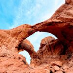
The Moki Dugway is a 3-mile unpaved road that drops 1,200 feet down a cliff face with 10% grades and hairpin turns. It connects Highway 261 to the valley floor and continues into Valley of the Gods.
What makes it great: The Dugway itself is an experience. It’s a graded dirt road built in 1958 to haul uranium ore, and it’s just scary enough to be fun without being actually dangerous (if you’re paying attention). Valley of the Gods at the bottom looks like a mini Monument Valley without the crowds.
Camping options: Dispersed camping throughout Valley of the Gods on BLM land. Tons of pulloffs where you can set up camp with incredible views of the sandstone buttes. It’s free and first-come, first-served.
Vehicle requirements: High clearance recommended. 2WD is usually fine in dry conditions since the road is maintained, but 4WD gives you peace of mind on the grades. If there’s been rain or snow, definitely want 4WD.
Pro tip: Drive it going down (south) instead of up. The views are better and it’s less sketchy. Also, time it for late afternoon light when the red rocks absolutely glow.
Permits/fees: None. It’s all BLM land and free to access.
What nobody tells you: There’s no cell service from the top of the Dugway through Valley of the Gods. Download maps beforehand. Also, if you’re scared of heights, maybe skip this one. The drop-off is right there next to the road with no guardrails.

Advanced Routes: Bring Recovery Gear
5. White Rim Trail
Distance: 100 miles | Time: 2-3 days | Difficulty: Difficult | Season: Spring & Fall (March-May, Sept-Nov)
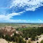
White Rim is the most famous overlanding route in Utah, and for good reason. It circles the Island in the Sky mesa in Canyonlands National Park, dropping 1,200 feet down the Shafer Trail and staying low the entire loop.
What makes it great: The scenery is absolutely unreal. You’re driving along cliff edges with thousand-foot drops, through narrow canyons, past ancient rock art, and camping in spots most people will never see. It’s challenging enough to feel like an accomplishment but not so technical that you need a built rig.
Camping options: There are 10 primitive campsites along the route, each with a pit toilet and nothing else. You have to reserve your sites through recreation.gov, and they book up 4-6 months in advance. No joke, people set alarms for when reservations open.
Vehicle requirements: High-clearance 4WD required, period. The park rangers will turn you away if you show up in anything less. The Hardscrabble Hill climb and Murphy’s Hogback descent are the technical cruxes. Low range gets used multiple times.
Pro tip: Do the loop clockwise. This puts the Shafer Trail descent at the beginning when you’re fresh and not exhausted. Also, start stupid early on day one. You want to hit Shafer in morning light, and you don’t want to be setting up camp in the dark.
Permits/fees: $30 vehicle permit + $20 per night camping fee. You also need a separate reservation for Shafer Trail if you’re starting from Island in the Sky.
What nobody tells you: It’s 100 miles of washboard roads. Everything in your truck will rattle loose. I use Rubbermaid Action Packers to keep gear from destroying itself. Also, bring way more water than you think you need. I went through 15 gallons over three days for two people.
Recovery gear checklist: Traction boards, recovery straps, shovel, full-size spare, tire repair kit, and a portable air compressor. I watched someone with street tires pop two sidewalls on the rocks and have to get towed out by a ranger.
For a complete gear list for trips like White Rim, check out our essential overlanding gear guide (coming soon).
6. Hole-in-the-Rock Road
Distance: 57 miles one-way | Time: 3-5 hours each way | Difficulty: Difficult | Season: Spring & Fall (avoid summer heat)
Hole-in-the-Rock Road runs from Highway 12 near Escalante down to Lake Powell. It follows the historic route Mormon pioneers used in 1879-80 to reach the Colorado River. The first 35 miles are rough but manageable. The last 22 miles are legitimate backcountry.
What makes it great: Solitude. Access to incredible slot canyons like Peek-a-Boo and Spooky Gulch. Devil’s Garden with its unique hoodoos. And the knowledge that you’re driving where wagons somehow made it through 145 years ago.
Camping options: Dispersed camping everywhere on BLM land. Some of the best camps are near Devil’s Garden around mile 12. Past mile 35, you’re pretty much on your own. Pick a spot, set up camp, enjoy the silence.
Vehicle requirements: High-clearance 4WD mandatory for going past the first 35 miles. Even the first section beats up 2WD vehicles. The road surface is a mix of sand, rock, and deep ruts. Aired-down tires help a lot.
Pro tip: Most people don’t drive the whole thing to Lake Powell. They go for the side trips to the slot canyons and Devil’s Garden, then turn around. That’s honestly the smart play unless you really want to say you made it to the end.
Permits/fees: None for the road itself. If you hike into certain slot canyons, you might need permits through the BLM.
What nobody tells you: The road conditions change constantly based on weather and maintenance. What was fine last month might be a rutted mess this month. Check recent trip reports before you go. Also, gas up in Escalante because there’s nothing past that.
Garmin inReach Mini 2 Satellite Communicator
7. Lockhart Basin
Distance: 60 miles (full loop) | Time: 6-8 hours | Difficulty: Very Difficult | Season: Spring & Fall
Lockhart Basin is for people who think White Rim is too easy. This loop in the Needles District of Canyonlands includes serious rock crawling, steep climbs, and some of the most remote terrain in Utah.
What makes it great: If you want to test your rig and your skills, this is it. The route includes sections of slickrock, loose rock climbs, narrow shelf roads, and obstacles that’ll make you think twice. It’s also stunningly beautiful and almost always empty.
Camping options: Several primitive sites along the route. Lockhart Basin campground at the bottom is first-come, first-served. Most people just find a pulloff and camp wherever looks good (on already disturbed ground).
Vehicle requirements: Built 4WD rig with skid plates, recovery points, and all-terrain or mud-terrain tires. This is not the place for a stock anything. Good articulation helps. Lockers are nice to have but not required if you know what you’re doing.
Pro tip: Don’t attempt this solo unless you’re very experienced. Go with at least one other vehicle and bring full recovery gear. Also, walk any obstacle you’re not sure about before you drive it.
Permits/fees: $30 Canyonlands entrance fee.
What nobody tells you: The climb out of Lockhart Basin back up to the mesa is gnarly. It’s loose rock, steep grades, and if you slide backwards you’re going to have a bad time. Also, there’s a reason this route doesn’t get much traffic. It’s genuinely difficult.
If you’re planning advanced routes like this, our camping essentials checklist covers everything you’ll need for remote backcountry camping.
Route Comparison: Which One is Right for You?
| Route | Distance | Days | 4WD Required? | Permits? | Best For |
|---|---|---|---|---|---|
| Alpine Loop | 20 mi | Half day | No | Fee area | Beginners, families |
| Mirror Lake Hwy | 42 mi | 1 day | No | Fee area | Easy scenic drive |
| Burr Trail | 66 mi | 1-2 days | No* | Free/NP fee | Intermediate skills |
| Moki Dugway/VOTG | 17 mi | 1 day | No* | Free | Views, photography |
| White Rim | 100 mi | 2-3 days | Yes | Required | Multi-day adventure |
| Hole-in-the-Rock | 57 mi | 1-2 days | Yes | Free | Slot canyons, solitude |
| Lockhart Basin | 60 mi | 1 day | Yes | NP fee | Technical challenge |
*High clearance strongly recommended
Essential Gear for Utah Overlanding
Navigation:
- Offline GPS maps (Gaia or onX)
- Physical maps as backup (cell service is a joke)
- Compass
Recovery gear (for advanced routes):
- Traction boards
- Recovery straps (not tow straps)
- Shovel
- Portable air compressor
- Tire repair kit
Water & supplies:
- 2+ gallons per person per day
- Extra for radiator/coolant
- Way more than you think you need
Communication:
- Satellite communicator for remote routes
- Two-way radios if traveling with others
Camping:
- Tent or rooftop tent
- Sleeping bag rated for cold nights (even summer)
- Camp stove and cookware
- Headlamp
For a complete breakdown of what to bring, check our best overlanding gear guide (coming soon).
Utah Overlanding Logistics: The Boring But Important Stuff
When to Go
Spring (March-May): Best weather, wildflowers blooming, rivers running high. Can still have snow at elevation. Popular routes book up fast.
Summer (June-August): Hot as hell in the desert (100°F+), but high-elevation routes like Alpine Loop and Mirror Lake are perfect. Afternoon thunderstorms are common.
Fall (September-November): My favorite season. Cooler temps, fall colors in the mountains, fewer crowds. Some high routes close by late October.
Winter (December-February): Most routes are closed or sketchy. Low-elevation desert routes are possible but check conditions.
Permits and Reservations
White Rim Trail: Reservations required through recreation.gov, book 4-6 months out
National Parks: Entrance fees apply ($30-35 per vehicle for 7 days)
BLM Land: Usually free, no permits needed for most areas
Dispersed Camping: Free on BLM and some National Forest land, follow Leave No Trace
Gas and Supplies
Gas stations are few and far between in Utah’s backcountry. Fill up in these towns before heading out:
- Moab (for White Rim, Lockhart Basin)
- Escalante or Boulder (for Hole-in-the-Rock, Burr Trail)
- Kamas (for Mirror Lake Highway)
- American Fork (for Alpine Loop)
Bring extra fuel for long routes. I carry a 5-gallon jerry can on White Rim just in case.
Frequently Asked Questions
Q: Can I do these routes in a stock truck or SUV?
Depends on the route. Alpine Loop and Mirror Lake Highway? Yeah, any vehicle works. Burr Trail and Moki Dugway? Stock high-clearance SUV or truck is fine in good conditions. White Rim, Hole-in-the-Rock, and Lockhart Basin? You need 4WD and you’re probably gonna scrape something even if you’re careful.
Q: What’s the best beginner overlanding route in Utah?
Alpine Loop Scenic Byway, hands down. It’s accessible, beautiful, has lots of camping, and gives you a taste of Utah’s scenery without requiring special equipment or skills. Mirror Lake Highway is a close second.
Q: Do I need a lifted truck with 35-inch tires?
For most Utah overlanding? No. I ran White Rim in a stock-height F150 with 33-inch all-terrain tires. Ground clearance matters more than lift. But if you’re doing Lockhart Basin or serious rock crawling near Moab, yeah, a built rig helps a lot.
Q: How far in advance do I need to book permits?
White Rim books up 4-6 months in advance, sometimes within hours of reservations opening. Most other routes don’t require permits or are first-come, first-served for camping. National Park entrance fees can be paid at the gate.
Q: Is it safe to go solo?
I’ve done solo trips on easier routes like Burr Trail and Moki Dugway without issues. But for remote, technical routes like White Rim or Hole-in-the-Rock? Go with at least one other vehicle. If something breaks or you get stuck, you want backup. At minimum, carry a satellite communicator so you can call for help.
Q: What’s the cell phone coverage like?
Terrible to non-existent on most of these routes. You’ll have service in towns and sometimes at high points, but assume you’ll be off-grid for the duration of your trip. Download your maps and trip plans before you leave pavement.
Q: Can I camp anywhere or are there restrictions?
On BLM land, you can camp pretty much anywhere that’s already been disturbed (don’t create new sites). National Parks and some National Forest areas require designated campsites. White Rim has specific numbered sites you must reserve. Always follow Leave No Trace principles.
Planning Your Utah Overlanding Trip: Where to Start
If you’re new to Utah overlanding, here’s my recommended progression:
First trip: Alpine Loop or Mirror Lake Highway. Get a feel for the state, test your gear, camp somewhere easy.
Second trip: Burr Trail or Moki Dugway with Valley of the Gods. Step up to dirt roads and dispersed camping, but nothing too technical.
Third trip: White Rim Trail. This is the big one. Make sure your rig is dialed, you have all the right gear, and you’re comfortable with multi-day backcountry camping.
After that: Hole-in-the-Rock for slot canyons and solitude, or Lockhart Basin if you want technical challenges.
Don’t rush it. Each trip teaches you something about your rig’s capabilities and your own skills. The trails will still be there next year.

Other Utah Overlanding Destinations Worth Exploring
This guide covers seven main routes, but Utah has way more to offer:
- San Rafael Swell: Tons of BLM roads and slot canyons between Price and Hanksville
- Moab Area Trails: Hell’s Revenge, Poison Spider Mesa, Pritchett Canyon for serious rock crawling
- Scenic Byway 12: Paved but one of the most beautiful drives in America
- House Range: Remote desert mountains in western Utah, almost nobody goes here
- La Sal Mountains: High alpine routes near Moab
For more Utah destinations and trip planning, check out our Utah Car Camping Guide.
Neighboring states also offer incredible overlanding:
Final Thoughts: Utah is Worth the Hype
Utah overlanding lives up to the reputation. The scenery is ridiculous, the routes are diverse, and there’s genuinely something for every skill level. But you gotta do your homework, bring the right gear, and respect how remote and unforgiving this landscape can be.
Start with the easier routes to build your skills and confidence. Work your way up to the multi-day backcountry trips. And always, always bring more water than you think you’ll need.
The backcountry is waiting. Just don’t be the person who shows up to White Rim in a 2WD rental car with street tires. The rangers have seen enough of that already.
What’s your experience with Utah overlanding? Any routes I missed or tips you’d add? Let me know.